
Tools used to gather data for mining and construction make use of innovative laser based-tools. It is used as laser survey equipment to collect data on the entire mine or construction site.
Scanning a Project
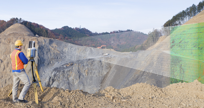
Laser survey equipment can be used to scan any area and collect multiple data points so that every detail is captured and proper mine planning can take place. It does so without interrupting the workflow of the area thanks to the effectivity of the laser used in the survey equipment.
The technology’s development has allowed for laser survey equipment to collect millions of points per every square kilometre. This is ideal for mining because there are many spatial changes in mining locations and one needs to have an exact calculation. This calculation informs the mine planning of data captured that reveals mine shafts and the volume of rock that is present. Laser survey equipment delivers accurate results better, faster and for less than most other methods of land surveying.
Mining Lasers
Mining lasers make the project planners aware of the possible geometric constraints that are present. This can be any number of things from shafts, passages and rock.
Terrestrial scanners allow for specific surveying techniques to be used so that nothing comes as a surprise when the mine is being opened. The use of mining lasers allows for the space to be mapped out in a 3D model so that everything can be seen and understood the way it is in reality from offsite.
The Polaris scanning system makes every little detail visible and is easy to use and transport. This make it perfect for travelling to and from mining sites in order to collect data. It makes of an oscillating motor without any gears to engage allowing it to quickly collect data.
A Cavity Monitoring System (CMS) is the ideal solution for scanning otherwise treacherous or completely inaccessible areas like cavities that could be much larger than they appear from the surface. With a CMS operators can stand at a safe distance while still collecting all the required and relevant data.
Construction Lasers
Construction lasers can monitor the progress of a construction site and as laser survey equipment goes it has become an integral part of the planning and development of new construction projects. Terrestrial scanners allow surveyors to collect data of points that are difficult or treacherous to reach otherwise.
The Maverick is lightweight and can be easily operated by one person. The Maverick lends itself well to a project of any size due to its unhindered capabilities in a wide range of conditions. Even indoor GNSS-deprived environments do not diminish the effectivity of the Maverick for scanning up to 700,00 data points per second.
This being said, making use of a Polaris system can then determine where pathways should be implemented in the construction. With the help of terrestrial scanners this can help determine if there should be passages, bridges or pathways built to reach all ends of the site.
Contact us for more information or browse through our products to see what land surveying equipment works best for your project.